With a strong commitment to sustainable development, SCGC has continuously supported the communities around Khao Yaida since 2007, focusing on ecosystem restoration and improving the quality of life for the community through key activities: ecosystem restoration, community empowerment, and education promotion.
SCGC has applied the structural and functional processes of the ecosystem as a guideline to address problems and restore the Khao Yaida ecosystem by (1) reducing flash floods and increasing water availability during the dry season through the construction of check dams, and (2) enhancing forest regeneration to accelerate the development of the plant community.
However, many conservationists have questioned what ecological principles SCGC employs as a framework for ecosystem restoration to meet the goals of sustainable development and efficient water management.
The answer lies in using the close interrelationship between "soil, water, and forest" as the fundamental approach. It begins with the evolution of ecosystems, which indicates that in terrestrial forest ecosystems, soil, water, and forest develop together, progressing from a bare rock surface to a stable climax forest.
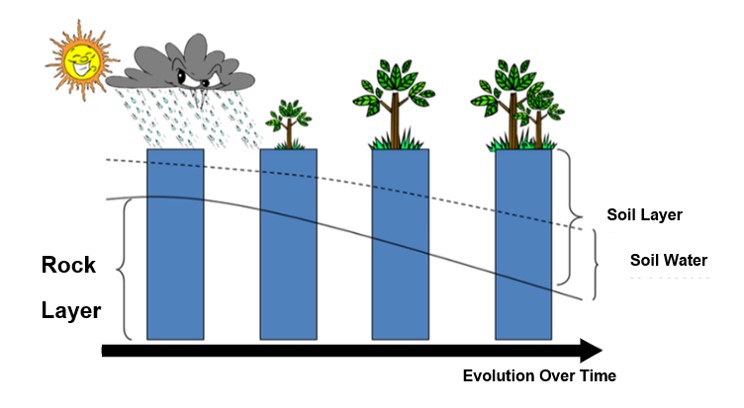
Rocks consist of various minerals, and these minerals contain different elements. Each element expands when heated by the sun during the day and contracts when cooled at night (in accordance with the law of energy conservation). This uneven expansion and contraction cause rocks to break into small particles on the surface. These small rock particles have a high capacity (F) to attract water vapor or moisture from the air in accordance with Newton's law of gravitation: F = (m1*m2)/d², where m1 is the mass of the small rock particles, m2 is the mass of the water vapor or moisture, and d is the distance between the small rock particles and the water vapor. When water vapor or moisture is attracted to the small rock particles, the process of water accumulation in the area begins.
Once moisture or water vapor is absorbed, and the reproductive cells of lower plants, such as lichens, are blown in and settle, life begins to emerge. This can be observed as thin, light blue layers on the rock surface, marking the start of plant community development. The presence of lichens accelerates the breakdown of rock particles, partly due to the penetration of roots, similar to how a Bodhi tree growing on a temple wall causes the wall to crack over time. As lichens die, their remains decompose and mix with rock fragments, forming soil. At this point, the soil formation process begins.

The soil that forms will be fine in texture and able to absorb more water vapor and/or moisture (which, if abundant, will condense into water droplets). This change makes the environment less suitable for lichens, allowing a new group of plants, mosses, to thrive in their place. The processes of soil formation, water accumulation in the soil layers, and the development of new plant communities will occur and cycle continuously. The soil layer will deepen, more water will be stored in the area, and plant communities will gradually evolve into larger trees. This transformation takes hundreds of thousands to millions of years. However, the evolution of animal communities remains largely unstudied.
Similarly, the development of plant communities from degraded forests due to wildfires and/or the conversion of forests into monoculture agricultural areas back to pristine or stable original forests requires thousands to hundreds of thousands of years, especially if left to natural processes.
Therefore, SCGC has drawn on the proven outcomes from the moisture-retaining check dams of the Huai Hong Khrai Royal Development Study Center in Doi Saket District, Chiang Mai Province, to develop the concept of reducing the recovery time of ecosystems. This approach suggests incorporating one of the key factors to support the three main processes: replenishing lost soil across the area, planting additional trees, and increasing water availability. The easiest factor to implement is increasing water availability in the area, which led to the creation of check dams to slow down water flow.
SCGC has adopted the approach of constructing check dams from the Huai Hong Khrai Royal Development Study Center in Doi Saket District, Chiang Mai Province. These check dams are built periodically along stream channels to increase surface and groundwater levels. Additionally, small contour ditches are dug on both sides of the upstream check dams to distribute moisture throughout the area, turning the check dams into wet firebreaks that reduce the intensity and spread of wildfires. These check dams also serve as a tool for controlling gully erosion, as recommended by the FAO. This approach has been adapted for watershed areas with rounded volcanic rocks intruding through marine sand layers resting on thick laterite surfaces at Khao Yaida. To ensure maximum efficiency in building these check dams, all participants are briefed on the correct principles of constructing water-retention check dams before each activity.
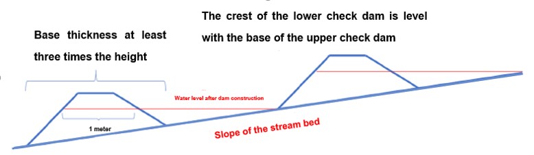
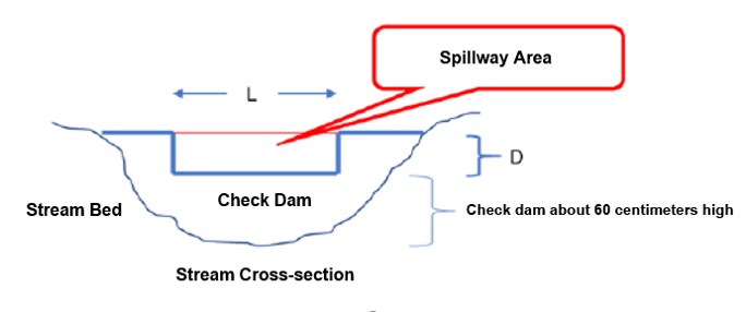
Since the materials used to construct the check dams at Khao Yaida are primarily stones, the check dams here are of the rock check dam type, with the following construction principles:
- Each check dam's crest should not exceed 60 centimeters above the stream bed. The crest at the spillway section should be approximately 1 meter thick, and the base thickness should be three times the height of the crest. This design allows the upstream slope of the dam to reduce the impact force of the inflowing water, while the downstream slope helps prevent water from rolling back and eroding the dam's foundation (as referenced by the FAO).
- The spacing between each check dam follows the guideline that the crest of the lower check dam must be at the same elevation as the base of the upper check dam. This creates a step-like pattern that effectively slows down the flow of runoff. According to studies by the Watershed Research Division of the Department of Conservation and Watershed Management, Department of National Parks, Wildlife, and Plant Conservation, this design can reduce the speed of water flow by 40 to 90%, depending on the volume of the runoff. Additionally, the slowed runoff helps suspended sediments in the water settle in front of the check dams instead of moving downstream, where they could cause siltation in dams or reservoirs in the lower areas. This process also reduces the waterway's capacity, which can lead to overflow and flooding during the rainy season. Conversely, it limits the amount of water available for downstream communities during the dry season because, during prolonged dry periods or after extended breaks between rains, most of the water moves beneath the sandy sediments in the streams and rivers. Both issues create significant hardship for the communities and incur considerable costs for the government, which must dredge the waterways almost every year.
- For the spillway of each check dam, the crest can be constructed in the shape of a speed bump or as a rectangular opening. The size of the spillway can be estimated using two mathematical equations: Equation 1: Qp = CIA, where Qp is the estimated peak runoff resulting from each rainfall event. This value is the product of three factors: C, the Runoff Coefficient, which represents the ratio of streamflow runoff to the total rainfall during that event and varies by location and time. I, the rainfall intensity, which is the ratio of the amount of rainfall divided by the duration of the rainfall event. A, the catchment area or the watershed area upstream of the check dam. Equation 2 uses the Qp value to determine the spillway size, assuming it is a rectangular channel with width L and depth D. The formula is Qp = 3.0LD³/², where 3.0 is a constant specific to Rock Check Dams, as illustrated in the diagram below.
Check dams help reduce the speed of runoff flowing in the stream, allowing water to seep into the soil beneath the stream bed and into the soil layers on both sides of the stream. Part of this water is absorbed by the trees along the stream banks, promoting their growth and enhancing the overall health of the forest. Another portion of the water gradually moves through the soil layers into shallow wells located at the foot of the slopes, ensuring that wells that were once dry before the construction of the check dams now hold water year-round. Examples include the well at Yaida Garden, owned by “Auntie Boonchuen,” in Tapong Subdistrict, Mueang Rayong District, and the shallow well supplying water to the Map Chan village tap water system in Klaeng Subdistrict, Mueang Rayong District. All of these are tangible outcomes observed in the communities surrounding Khao Yaida.
In terms of academic data, SCGC has applied the Runoff Curve Number Modelof the Natural Resources Conservation Service (NRCS) from the United States to evaluate monthly runoff before and after the construction of check dams. The results show that after constructing 6,000 check dams, out of a total planned 18,464, the existing dams have reduced peak runoff by 2.75% and increased water availability during the dry season by 7.48%. Additionally, the flow of water in the streams during the dry season has been extended by an additional three months. Similarly, an analysis of forest health using theNormalized Difference Vegetation Index (NDVI),which utilizes data from satellite imagery as an indicator, revealed that within 2-3 years after the start of the check dam construction (comparing data from years with equal Antecedent Precipitation Index or API values), the forest at Khao Yaida has shown an increase in health and density by 6.55 to 14.08%.
“Soil-Water-Forest”: Ecological Development for Sustainability by SCGC
SCGC has been supporting the communities around Khao Yaida in restoring their ecosystems upon request since 2007. This support was necessitated by the prolonged water scarcity these communities have faced, caused by (1) timber concessions granted since 1949 and (2) encroachment on forest areas for monoculture agriculture, often involving slash-and-burn practices. This has led to the drying up of streams originating from the Khao Yaida watershed, which previously flowed year-round. Now, these streams dry up shortly after the rainy season, typically from late November to early May each year, preventing any fish species from migrating upstream to spawn in the watershed (which typically occurs in February and March each year).
SCGC has integrated ecological knowledge, particularly the close interrelationship between soil, water, and forests, with insights from the outcomes of the check dams constructed by the Huai Hong Khrai Royal Development Study Center in Doi Saket District, Chiang Mai Province. This approach has developed into a strategy for accelerating ecosystem restoration, rather than relying on natural recovery, which would take a very long time and would not address the community's immediate needs. By increasing water availability in the area, trees can grow more rapidly, which in turn accelerates soil formation. The soil helps enhance water retention through the construction of check dams that reduce runoff and increase groundwater. As a result, shallow wells at the foothills, which were previously dry during the dry season, now have water throughout the year. At the same time, the increased groundwater is partially absorbed by trees in the forest, promoting their growth and improving forest health. Furthermore, planting a variety of tree species contributes to greater biodiversity in the area.
SCGC has also developed an Antecedent Precipitation Index (API) Model to identify the appropriate time periods for comparing forest health before and after the construction of check dams. Satellite images from both time periods were then used to calculate the Normalized Difference Vegetation Index (NDVI), which was chosen as an indicator for comparison. The results showed that forest health had improved. Similarly, in terms of reducing runoff and increasing water availability during the dry season, SCGC applied the principles of the Runoff Curve Number Model from the NRCS to develop a monthly runoff model, which was used to analyze changes in runoff resulting from the construction of check dams.
However, there remains a need for monitoring actual runoff data from every stream flowing down from the Khao Yaida mountain range, with the surrounding communities conducting the measurements themselves. Currently, SCGC, in collaboration with the Thailand Science Research and Innovation (TSRI), is developing community researchers by employing Community-Based Research (CBR) as a tool. This initiative aims to develop local people while restoring the watershed ecosystem, with the goal of empowering the communities around Khao Yaida to sustainably restore their ecosystems and solve their local problems independently in the future.
______________________________________________
References:
- Kittipong Pongboon, Pradit Sripattanasuwan, Somchai Onarsa, Samroeng Panuthai, Boonma Deesaeng, and Jamnian Phuanda. 2011. "Impacts of Forest Fires on Soil and Water Loss in Watershed Areas." Watershed Research Division, Department of National Parks, Wildlife, and Plant Conservation. 9 pages.
- 2024. “Watching the Belly Barb in Nan.” Department of Fisheries. 10 pages.
- 2024. “Thousands of Belly Barbs Swimming Upstream to Spawn.” Thai PBS. https://www.thaipbs.or.th/news/content/250631